
 By
By The United Nations General Assembly has voted overwhelmingly to encourage a shift away from the centuries-old Mercator world map, endorsing instead projections that show Africa and other equatorial regions at their true relative size, in a resolution African governments spent years building toward and now describe as a matter of historical justice.
The Vote
Meeting on Thursday, September 4, the General Assembly adopted the resolution titled “Correct the map: rebalancing global cartographic representation and promoting equitable representation of the world’s regions, particularly Africa” by a recorded vote of 164 in favour, one against and six abstentions.
The United States cast the sole vote against the measure. Estonia, Georgia, Lithuania, Moldova, Serbia and Ukraine abstained.
The resolution was introduced by Togo on behalf of the African Group, the bloc of 54 African member states at the UN, with the Bahamas also among its sponsors, and had the backing of the African Union as a whole.
The measure does not ban the Mercator projection or mandate a single replacement. Instead, it encourages governments, schools, international organizations, and technology companies to adopt the Equal Earth projection and other equal-area maps whenever the relative size of continents matters and to teach the inherent limitations of any flat map attempting to represent a spherical planet.
What the Mercator Map Gets Wrong
The projection at the centre of the debate was devised in 1569 by Flemish cartographer Gerardus Mercator to solve a specific navigational problem. Because straight lines on a Mercator map correspond to constant compass bearings, sailors could use it to plot courses with a ruler, a genuine breakthrough for 16th-century maritime navigation that remains useful for that narrow purpose today.
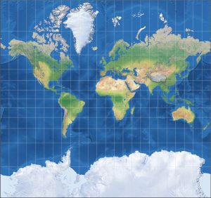
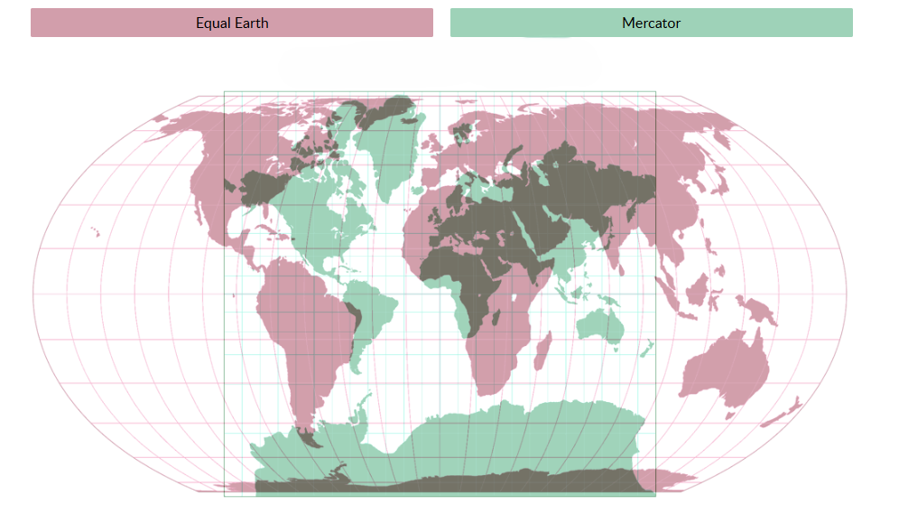
The trade-off is area, as the projection stretches landmasses more severely the farther they sit from the equator, so countries and regions near the poles appear dramatically larger than they actually are relative to those near the equator.
The starkest example is also the most cited, Greenland appears on a Mercator map as roughly comparable in size to Africa, when in reality Africa is about 14 times larger, large enough to contain the mainland United States, China, India, and most of Europe combined. Europe, Russia and North America are all similarly inflated relative to their true proportions, while Africa, South America and South Asia shrink by comparison.
Despite these known distortions and despite geographers having advised against its use as a general reference map for decades, Mercator has remained the default projection in classrooms, atlases, news broadcasts and much of the world’s digital mapping infrastructure for more than four centuries. Mark Monmonier, a Distinguished Professor Emeritus of Geography at Syracuse University who has written extensively on how maps can mislead, has previously described the projection as obsolete for general use, noting that geographers have long cautioned against treating it as anything other than a navigational tool.
Where the Campaign Came From
The resolution did not emerge overnight. The African Union formally adopted the Equal Earth map in March, following years of advocacy from African cartographers, historians and civil society groups arguing that the visual shrinking of the continent has real consequences for how it is perceived globally, in education, media, diplomacy, and economic decision-making alike.
Following that adoption, Togo, acting on the AU’s behalf, formally asked UN member states in April to follow suit, leading to a draft resolution and a round of informal consultations at the UN in July before Thursday’s vote.
Amma Twum-Amoah, the AU’s Commissioner for Health, Humanitarian Affairs and Social Development, framed the campaign’s stakes in a statement issued in March, arguing that Africa, long diminished on maps, was now insisting on being seen at its true scale across every register, geographic, historical, moral, cultural, economic, diplomatic and global.
The African Union’s push built on a broader, decades-old body of scholarship and activism describing the Mercator map’s distortions as an inheritance of the colonial era that has never been fully corrected.
Togo Makes the Case
Togo’s Foreign Minister, Robert Dussey, who led the negotiations on the resolution, argued before the vote that maps do far more than represent geography.
He said maps shape how people understand the world, guiding education, feeding the imagination, and shaping collective perceptions in ways that are rarely questioned once a particular map becomes the default.
Furthermore, he was careful, however, to frame the effort as forward-looking rather than punitive toward Mercator itself, acknowledging its continued navigational usefulness and stressing that the resolution does not seek to impose a single mandatory projection.
His closing framing of the issue captured the resolution’s core argument succinctly: a fair map does not change the geography of the world, it changes how the world is seen.
The resolution itself describes correcting these distortions as a matter of cognitive justice and memorial reparation, language that proved central to the sharpest disagreement over the measure.
The Equal Earth Alternative
The projection the resolution points to as an alternative, Equal Earth, was developed in 2018 by cartographers Tom Patterson, Bernhard Jenny and Bojan Šavrič and unveiled at the North American Cartographic Information Society conference that year.
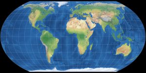
Unlike Mercator, Equal Earth preserves the relative size of landmasses accurately, at the cost of some distortion to their shape, a trade-off inherent to any attempt at flattening a curved surface.
Patterson, a former senior cartographer with the US National Park Service, has previously said publicly that Mercator can create a misleading impression when used as a general-purpose world map rather than the navigational chart it was designed to be.
Equal Earth is not without its own reshuffling effects. Under it, Europe appears visibly smaller than on a Mercator map, Brazil appears notably larger, and Greenland shrinks dramatically to reflect its true, comparatively modest size.
Versions of the map also exist that shift the visual centre away from the traditional Greenwich, London orientation, including one that centres Oceania, a region that has voiced its own long-standing frustration with how conventional maps marginalise it visually.
New Zealand, positioned at the bottom right corner of most standard world maps, memorably joked in a 2018 tourism campaign fronted by then Prime Minister Jacinda Ardern that the country was disappearing off the world’s maps entirely.
The United States Objects
Washington’s opposition centred not on cartography itself but on the political framing the resolution attached to it.
The American representative told the Assembly that the resolution mocked the institution’s work and purpose, describing it as part of a far larger and more radical ideological project than its cartographic surface suggested.
The US representative singled out the resolution’s references to reparations and cognitive justice specifically, characterising initiatives built around that language as damaging to the UN’s credibility.
A Notable Defection to the African Position
In a move that evidenced how the debate cuts across old geographic and political lines rather than a simple global North versus South split, France announced hours before the vote that it would abandon the Mercator projection for its own official world maps, aligning itself with the AU-led push.
French Foreign Minister Jean-Noël Barrot confirmed the shift, which means France itself will now appear visibly smaller relative to equatorial countries on official French maps, alongside the United States and Russia, all of which lose visual bulk under an equal area projection.
The move illustrates a point cartographers have repeatedly stressed throughout this debate: that equal area maps do not enlarge Africa; they simply remove the exaggeration Mercator has always applied to landmasses closer to the poles.
Ukraine’s Objection and the EU’s Careful Line
The six abstaining countries did not object to the underlying cartographic argument so much as to a specific downstream concern.
Ukraine said it supported the broader effort to correct historical distortions affecting Africa and the wider Global South but objected to how certain Equal Earth-based maps depict Ukrainian territory currently occupied by Russia, warning that endorsing the projection without adequate safeguards risked opening what its representative called a Pandora’s box, allowing map choices to blur questions of disputed territory and sovereignty.
The European Union, which supported the resolution as a bloc, addressed this same tension directly in its explanation of the vote, delivered on its behalf by Ireland.
The EU stressed that the resolution’s scope is strictly limited to the relative size of landmasses for educational, scientific, and awareness-raising purposes and explicitly does not touch questions of sovereignty, territorial status, or internationally recognized borders.
The bloc further clarified that its support for the resolution should not be read as an endorsement of any specific maps published on the Equal Earth website, a careful distinction aimed at separating the projection’s technical merits from any particular cartographer’s depiction of contested borders.
What the Resolution Does Not Do
The measure is explicitly non-binding, as it does not outlaw the Mercator projection, which will remain in wide use for navigation and in countless existing textbooks, atlases and digital tools for the foreseeable future. Nor does it mandate that any government, school system, or technology company switch projections by any deadline. What it does is lend near-unanimous international political weight to an argument African governments have pressed with growing organization over the past several years, that the choices societies make about how they draw the world are not neutral, and that correcting a 450-year-old cartographic default is a legitimate and achievable act of redress, however symbolic, alongside the continent’s other long-running pushes for greater representation in bodies like the UN Security Council.
Background
The vote arrives amid a broader pattern of African-led initiatives at the UN and African Union level pressing for revised historical narratives and more equitable global representation, including recent General Assembly debates on reparations for the transatlantic slave trade and continued African calls for permanent representation on the UN Security Council.
Whether the Correct the Map resolution meaningfully shifts how governments, publishers, and technology platforms render the world in the years ahead remains to be seen, but its passage marks the first time the question of cartographic bias has been formally taken up and endorsed at this scale by the world body.